Seychelles’ first maps and cartography exhibition to tour Indian Ocean region
Arts & Culture |Author: Rita Joubert-Lawen Edited by: Betymie Bonnelame | October 9, 2023, Monday @ 15:07| 38268 views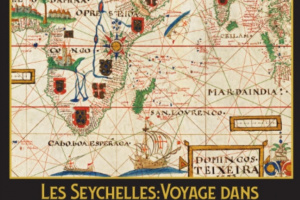
An exhibition that explores Seychelles' history through maps and cartography (Seychelles National Art Gallery)
(Seychelles News Agency) - Seychelles’ Ministry for Fisheries and Blue Economy has announced the launch of the first ever maritime maps and cartography exhibition due to open in the new Seychelles National Art Gallery in the capital of Victoria.
The exhibition will start on November 7, titled “The Seychelles: A Journey through the History of Maps (1482-1830)”, which will mark the opening of the Gallery, which closed in 2018 when the National Library closed down due to a fungus infestation.
“The project is the merging of culture, Blue Economy, the ocean and history,” said fisheries minister Jean François Ferrari in a press conference held at the Blue Economy department headquarters on Friday morning.
“I have always had a passion for old world maps, because each time I look at one it tells me a story,” Ferrari added.
The maps to be used in the exhibition are ones found in museums all over Europe and they all have a connection with the Indian Ocean.
“There are the Portuguese, the Spanish and the French who retrace the history, and for me it was important to do something as the Minister for the Blue Economy to show the Seychellois people that in the Blue Economy there is not just the sea, but there are aspects of tourism and culture as well,” he expanded.
The organisers say the exhibition is one that will trace Seychelles’ history through various maps.
“It is an invitation to the people to re-discover their history,” added Ferrari.
The exhibition is fully funded by private individuals, who share a common interest in history and art, including Brigadier Michael Rosette, Patrick Berlouis, Charles Morel, Bernard Shamlaye, Bernard Georges, Tony Mathiot, Glynn Burridge, Philippe Michaud, among others.
Once the exhibition closes in Seychelles, it will later tour the Indian Ocean in neighbouring islands, such Mauritius and Reunion Island, “because this is our common history, and we want all the people of the region to join us.”
Open for two months, people willing to view the exhibition will need to pay an entry fee, while children will be able to view the exhibits free of charge.
“Culture is everyone’s business and this is a clear example of how it is associated with everything… It is important for everyone – especially the youth to learn more about our history,” said the secretary general of the Seychelles National Institute of Culture, Heritage and the Arts (SNICHA), David Andre, at the press conference.
Seychelles’ President Wavel Ramkalawan had appointed Richard Touboule, a French historian, to lead the team mounting the exhibition.
“The maps are what give us an idea of the Seychelles history, the country’s history is the sea and the ocean – so this exhibition will be taking us on a voyage through the maps we have available,” said Touboule.
The maps on show will detail half a century of Seychelles’ history and Touboule said it is the first of its kind organised in the Indian Ocean.
About 90 percent of the maps showing Seychelles' history were obtained from museums in France, which have been carefully chosen to “interest the people”, he added.
In total, there will be around 40 maps and models of ships that sailed the Indian Ocean on show.
“We will be showing exceptional old artefacts linked to navigation and astronomy,” explained Touboule.